


Table of Contents for this page:
Overview of the Area
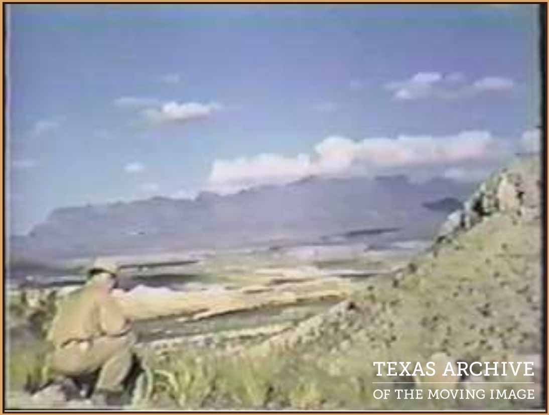
Get a rare ticket to travel back to 1939 to see Terlingua, Big Bend area, Presidio, Alpine, and San Carlos as they were then. Click the image below to see a 1939 movie of the area.
Cemeteries
|
Alpine Holy Angels Cemetery
Barstow Cemetery
Buena Vista Cemetery
Calsbad Cemetery
La Coyota Cemetery
Ft. Davis Cemetery
Ft. Stockton St. Joseph's Cemetery
García Family Cemetery
Study Butte Cemetery
Imperial Cemetery
|
Lajitas Cemetery
Marathon Cemetery
Marfa Cemetery
Molinar Family Cemetery
Ojinaga Cemetery
Pecos Cemetery
El Polvo Cemetery
Shafter Cemetery
Terlingua Cemetery
|
Counties
Texas County Boundaries
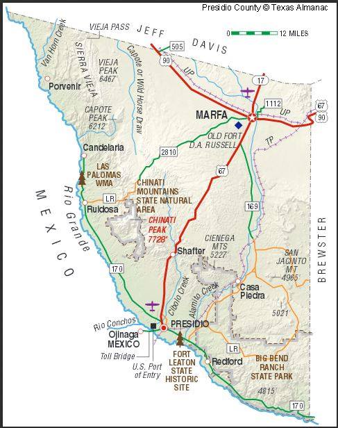
Places in Brewster County
Places in Presidio County
[This section needs to be added.]
Maps
Texas General Land Office Land/Lease Map Viewer https://gisweb.glo.texas.gov/glomapjs/index.html
Texas Railroad Commission GIS maps https://gis.rrc.texas.gov/GISViewer/
Mountains
and other Geological Places of Interest such as peaks, springs, et cetera.
and other Geological Places of Interest such as peaks, springs, et cetera.
Casa Grande
Christmas Mountain
Domíguez Mounatian (Domínguez Creek; Domínguez Mountain Trail)
Nine Points
Mule Ears
Santiago Peak
Santa Elena Canyon
Christmas Mountain
Domíguez Mounatian (Domínguez Creek; Domínguez Mountain Trail)
Nine Points
Mule Ears
Santiago Peak
Santa Elena Canyon
La Cuesta
Post Offices
The US Archives for Post Offices can be found at https://catalog.archives.gov/id/68741390
Towns and Settlements
includes farms, ranches, haciendas, ejidos, settlements, towns, municipalities, and counties
includes farms, ranches, haciendas, ejidos, settlements, towns, municipalities, and counties
|
Alpine
Boquillas (aka Rio Grande Village) Campo Nuevo (aka Study Butte) Candelaria (30.16086 -104.683289) Castolón (first known as Santa Elena) La Coyota (29.153810,-103.549300) La Coyota 1930 Census La Coyota Cemetery (Lat/Lng: 29.150500,-103.544444) Chisos (aka Terlingua) Dysart Ranch (in Presidio?) Fort Leaton Fort Stockton Barney Riggs Glen Springs Gordexola, Vizcaya, España (Molinar origins) Hot Springs El Indio (29.720869, -104.531502) Julimes, Chihuahua , MX (28.426201 -105.431084) La Junta de los Rios Kokernot Ranch Lajitas Marathon Molinar School El Mulato Murcia history
|
Meoqui [news of Meoqui]
(aka Pedro Meoqui, San Pablo Meoqui and Meoquis) Civil Records for Meoqui 1861 - 1992 Parral, Chihuahua, Mexico Presidio County Presidio, Texas El Pueblito Rooney's Place Pueblo Nuevo Pueblo Viejo Rancho del Alamo Redford aka Polvo Rooney's Place San Pablo Meoqui (see Meoqui) Shafter -- Link to Map Shafter - link to Birds Eye View Study Butte (aka Campo Nuevo) San Antonio, Chihuahua, MX (28.84611, -103.85548) Santa Elena, TX (Santa Elena's name later changed to Castolón) Ejido Santa Elena, MX Santa Elena Canyon Las Tapias Terlingua Terlingua map - read "Where is Terlingua?" (Lat/Lng: 29.32090609898411, -103.61694757388108) Terlingua Cemetary Terlingua Abajo (Lat/Lng: 29.1987735094371, -103.60425563655289) Terlingua-Study Butte |
Travel Routes
Indian Trails
Comanche Trail aka Comanche Trace https://en.wikipedia.org/wiki/Comanche_Trail
Note: You may notice the word "Ejido" on Mexican locations. Curious? Click here to check it out; learn what about ejidos in Mexican history.
Drives - take a video drive
Texas FM 179 Presidio to Terlingua - YouTube video 12 mins 26 seconds:
Drive The River Road: Texas FM 179 - Presidio to Terlingua
Drive The River Road: Texas FM 179 - Presidio to Terlingua
Ross Maxwell Scenic Drive Terlingua to Santa Elena Canyon - YouTube video
Drive Terlingua to Santa Elena Canyon on Ross Maxwell Scenic Drive through BBNP.
Drive Terlingua to Santa Elena Canyon on Ross Maxwell Scenic Drive through BBNP.
Railways
The Galveston, Harrisburg, & San Antonio Railroad
"In 1868, it changed owners and became the Galveston, Harrisburg, & San Antonio Railroad. More tracks were then laid towards San Antonio and the new owners also constructed the first telegraphs along the route. After reaching San Antonio, the road was continued to El Paso, where it met the Southern Pacific Railroad and insured that the line’s transcontinental route would use the southern portion of Texas rather than the north. The railroad itself used the nickname Sunset Route, a name that was in general use by 1874 and was later adopted by the Southern Pacific Railroad for the entire line between New Orleans and Los Angeles, California. As early as 1878 the railroad reached an agreement with the Southern Pacific Railroad, regarding the expansion of the Galveston, Harrisburg and San Antonio west of San Antonio. The two companies met up in January 1883 with a silver spike driven just west of the Pecos River to mark the completion of a new transcontinental route across Texas." read more
"In 1868, it changed owners and became the Galveston, Harrisburg, & San Antonio Railroad. More tracks were then laid towards San Antonio and the new owners also constructed the first telegraphs along the route. After reaching San Antonio, the road was continued to El Paso, where it met the Southern Pacific Railroad and insured that the line’s transcontinental route would use the southern portion of Texas rather than the north. The railroad itself used the nickname Sunset Route, a name that was in general use by 1874 and was later adopted by the Southern Pacific Railroad for the entire line between New Orleans and Los Angeles, California. As early as 1878 the railroad reached an agreement with the Southern Pacific Railroad, regarding the expansion of the Galveston, Harrisburg and San Antonio west of San Antonio. The two companies met up in January 1883 with a silver spike driven just west of the Pecos River to mark the completion of a new transcontinental route across Texas." read more
The Gulf, Colorado and Santa Fe Railway
https://en.wikipedia.org/wiki/Gulf,_Colorado_and_Santa_Fe_Railway
https://en.wikipedia.org/wiki/Gulf,_Colorado_and_Santa_Fe_Railway
This page was created on November 20, 2013. Revamping of this page was started on November 18 2020.
Revamping on this page continued on March 14, 2021. Additional revamping on August 10, 2021.
Revamping on this page continued on March 14, 2021. Additional revamping on August 10, 2021.
Spain Maps:
https://www.familysearch.org/search/tree/results?treeref=G3TG-8VK&q.givenName=Mar%C3%ADa&q.surname=S%C3%A1ez&q.birthLikePlace=Gordejuela%2C%20Biscay%2C%20Basque%20Country%2C%20Spain&q.birthLikeDate.from=1488&q.birthLikeDate.to=1492&q.deathLikePlace=Gordejuela%2C%20Biscay%2C%20Basque%20Country%2C%20Spain&q.deathLikeDate.from=1588&q.deathLikeDate.to=1592Spain maps
https://www.familysearch.org/search/tree/results?treeref=G3TG-8VK&q.givenName=Mar%C3%ADa&q.surname=S%C3%A1ez&q.birthLikePlace=Gordejuela%2C%20Biscay%2C%20Basque%20Country%2C%20Spain&q.birthLikeDate.from=1488&q.birthLikeDate.to=1492&q.deathLikePlace=Gordejuela%2C%20Biscay%2C%20Basque%20Country%2C%20Spain&q.deathLikeDate.from=1588&q.deathLikeDate.to=1592Spain maps
This page is a work in process. Some parts of it may not yet work.
Working Notes: This page needs to have the Table of Contents completed by adding sections missing and adding subsection headings where appropriate. Then all locations in the Table of Contents needs to be linked to the beginning of its section.
